This walk sets the pattern of several to follow, beginning with a climb up onto the South Downs ridge from the starting point, a dip in the middle to a dry valley and a further ascent, finishing with a downhill walk to the finish.
From Cocking Car Park (details here) the chalk path climbs up through fields to reach the high escarpments, nature reserves and wildlife corridors of of Heyshott and Grafham Downs. There is plenty of woodland on either side but the path becomes quite level until it begins to descend across the fields of Littleton Down to the A285 Chichester to Petworth road. From here it ascends again to the Roman road of Stane Street and Bignor Hill. Then after an undulating ridge walk the SDW descends past Bury Hill where it crosses the fast and furious A29 to the River Arun and Amberley where – with luck, a fine cream tea awaits at the Riverside Tearooms.
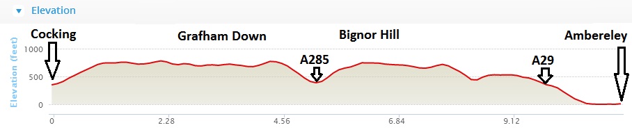 The uphills involved are not excessively taxing since at Cocking you start the climb at almost 400 feet above sea level. The trail only rises about 360 feet to Heyshott and Grafham Downs. And after the A285 there is only a further 250 feet to climb up before the long descent to Amberley. In total you ascend just 627 feet on this walk.